


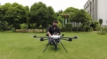
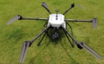
AirSpectral Drone with microHSI™ 410 SHARK Hyperspectral Camera
Original price was: ₹8,020,000.00.₹4,950,000.00Current price is: ₹4,950,000.00.
AirSpectral Drone with microHSI™ 410 SHARK Hyperspectral Camera
Capture high-resolution hyperspectral data from the air with precision and ease. Designed for agriculture, environmental monitoring, geology, and research, the AirSpectral Drone integrates the lightweight microHSI™ 410 SHARK camera to deliver detailed, georeferenced spectral imaging—unlocking powerful insights that go beyond traditional aerial surveys.
AirSpectral Drone with microHSI™ 410 SHARK Hyperspectral Camera
Advanced Aerial Hyperspectral Imaging for Precise Data-Driven Decisions
The AirSpectral Drone is engineered to transform how industries and researchers capture and analyze spectral data from the sky. Equipped with the powerful microHSI™ 410 SHARK Hyperspectral Camera, this drone offers exceptional performance in a lightweight, fully integrated aerial system.
High-Resolution Hyperspectral Imaging
Capture detailed spectral data across the visible and near-infrared range (400–1000 nm). The microHSI™ 410 SHARK delivers high spectral and spatial resolution, allowing you to detect subtle differences in vegetation, materials, and surfaces that are invisible to conventional cameras.
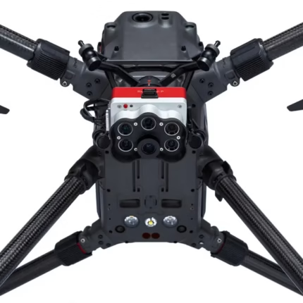
Purpose-Built Drone Integration
Designed specifically for hyperspectral mapping, the AirSpectral Drone features:
-
Vibration-isolated mounting and stabilized gimbal for crystal-clear data
-
Precise GPS/INS for accurate georeferenced maps
-
Long-endurance flights are

DCIM100MEDIADJI_0308.JPG
ideal for surveying large areas in a single mission
-
Autonomous waypoint navigation for repeatable and consistent data collection

Applications Across Industries
Whether you’re a researcher, consultant, or enterprise operator, the AirSpectral Drone empowers a wide range of applications:
-
Precision agriculture: Crop health analysis, disease detection, and nutrient mapping
-
Environmental monitoring: Water quality assessment, vegetation stress detection, and land cover classification
-
Geology and mining: Mineral mapping and material identification
-
Forestry: Species classification, canopy health monitoring, and biomass estimation
-
Industrial & heritage: Surface inspection, material differentiation, and conservation planning
Ready to Fly, Easy to Use
From mission planning to data analysis, the AirSpectral Drone is designed for streamlined workflows:
-
Intuitive ground control software
-
Real-time data preview and quality checks
-
Compatibility with leading hyperspectral processing tools
Discover the future of aerial spectral intelligence.
Contact us to schedule a demo or learn how the AirSpectral Drone can elevate your projects.

Related products


Reviews
Clear filtersThere are no reviews yet.