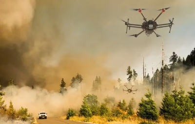
Disaster Monitoring
Inspection with drones has transformed disaster response. They provide real-time aerial insights for faster, more informed decision-making. Surveillance drones come packed with high-resolution cameras, thermal sensors, and outstanding technology. They quickly assess damage, locate survivors, and support relief efforts with unmatched precision. From tracking wildfires to monitoring floods and earthquakes, drones deliver critical data in real-time. When every second counts, they ensure a faster, more effective disaster response.
Road And Railway Surveillance
Surveillance drones are transforming transportation monitoring. They provide real-time aerial insights into roadways and rail networks. Equipped with high-resolution cameras and advanced sensors, these UAVs inspect infrastructure with precision. They detect damages and identify hazards before they escalate. By using drones for inspection, authorities can ensure smoother traffic flow and prevent accidents. They help maintain rail and road networks with greater efficiency and accuracy.
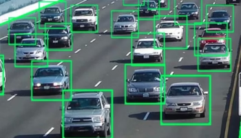
Road Traffic Surveillance
Surveillance drones are transforming traffic management. They provide real-time aerial insights into road conditions. Equipped with high-resolution cameras and advanced sensors, these UAVs monitor congestion and detect accidents. They enhance traffic control with unmatched precision. By using drones for inspection, authorities can optimize traffic flow and reduce bottlenecks. They improve road safety like never before.
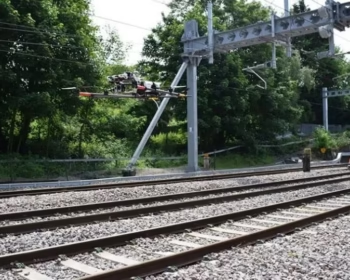
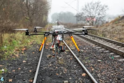
Railway Track Inspection
Drones with thermal technology are revolutionizing railway maintenance. They provide precise, real-time monitoring of track conditions. Equipped with infrared imaging, these surveillance drones detect structural defects and overheating components. They identify potential hazards before they lead to failures. By using aerial thermal inspections, railway operators can enhance safety and efficiency. They ensure cost-effective maintenance while minimizing risks and preventing disruptions.
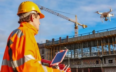
Construction Site Monitoring
Surveillance drones are revolutionizing construction site management. They provide real-time aerial monitoring of projects. Equipped with high-resolution cameras and advanced sensors, these UAVs track progress and inspect structures. They also enhance site security with unmatched accuracy. By using drones for inspection, construction teams can identify risks and improve efficiency. They ensure projects stay on schedule—all from a bird’s-eye view.
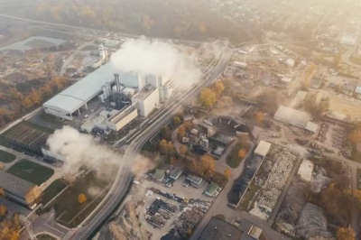
Pollution Monitoring
Surveillance drones are transforming air quality assessment. They provide real-time, high-precision data from even the most inaccessible locations. Equipped with advanced sensors and imaging systems, these UAVs detect pollutants and track environmental changes. They monitor industrial emissions with unmatched efficiency. By using drones for inspection, authorities can take proactive steps to combat pollution. This ensures cleaner air and a healthier environment for all.
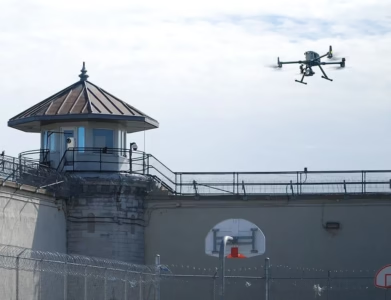
Security Purposes
Surveillance drones are revolutionizing security and monitoring. Equipped with advanced cameras, sensors, and real-time communication systems, they provide unmatched aerial surveillance. These UAVs detect threats and enhance perimeter protection across various environments. From public spaces to high-security zones, they ensure constant vigilance. By using drones for inspection, security operations become more efficient and proactive. They create a safer and more controlled environment with ease.
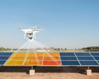
Solar Power Plant Inspection
Drones with thermal imaging are transforming solar power plant maintenance. They provide fast, real-time detection of panel defects and inefficiencies. Equipped with advanced thermal cameras, these surveillance drones spot overheating issues with precision. They ensure optimal performance and energy output. By using aerial thermal inspections, operators can identify faults early and reduce maintenance costs. This makes solar power management more efficient and reliable than ever.
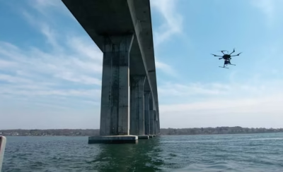
Bridge Inspection
Drones with thermal imaging are revolutionizing bridge maintenance. They provide accurate, real-time structural assessments with ease. Equipped with infrared cameras, these surveillance drones detect temperature variations, cracks, and hidden defects. They ensure early identification of potential issues. By using aerial thermal inspections, engineers can enhance safety and reduce manual inspections. This extends the bridge's lifespan while making infrastructure monitoring more efficient and cost-effective.
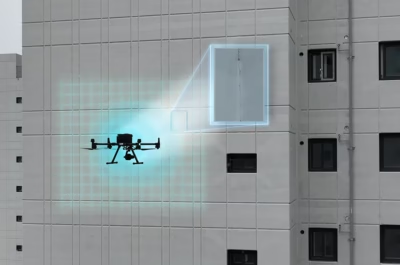
Building Outer Wall Crack Detection
Drones with thermal imaging are transforming building exterior inspections. They provide a fast, accurate way to detect structural issues. Equipped with infrared thermography, these surveillance drones spot hidden cracks, moisture intrusion, and insulation failures with precision. By using aerial thermal inspections, maintenance teams can prevent structural damage and enhance safety. This reduces repair costs and ensures long-term durability and stability.
Chimney Inspection
Drones with thermal imaging are revolutionizing chimney inspections. They provide a fast, efficient way to assess structural conditions. Equipped with infrared technology, these surveillance drones detect heat loss, cracks, and blockages with precision. By using aerial thermal inspections, operators can identify issues early and improve maintenance efficiency. This ensures optimal chimney functionality with minimal downtime.
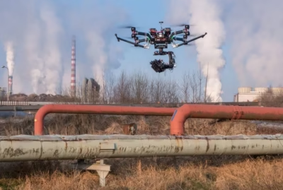
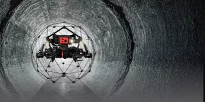
Pipeline Inspection
Inspection with drones is revolutionizing pipeline monitoring by providing real-time, high-precision assessments over vast distances. Equipped with temperature sensors, high-resolution cameras, and advanced monitoring tools, surveillance drones detect leaks, structural weaknesses, and corrosion with unmatched efficiency. By leveraging aerial inspections, operators can enhance safety, prevent failures, and reduce maintenance costs, ensuring seamless and reliable pipeline operations.
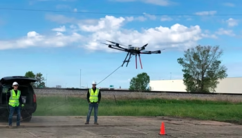
Wire Stringing
Inspection with drones has revolutionized wire stringing, offering a faster, safer, and more efficient alternative to traditional methods. Surveillance drones with specialized tools navigate difficult terrains, accurately laying cables across power lines, telecom towers, and other infrastructures with minimal disruption. By leveraging drone technology, industries can reduce labor risks, reduce project time, and enhance precision, making wire stringing more streamlined and cost-effective.
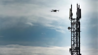
Cell Tower Inspection
Inspection with drones is transforming cell tower maintenance by providing high-precision, real-time assessments without the need for risky manual climbs. Surveillance drones equipped with advanced cameras and sensors inspect structural integrity, detect faults, and accurately assess equipment conditions. By utilizing aerial inspections, operators can enhance safety, reduce downtime, and optimize maintenance efficiency, ensuring uninterrupted network performance.

Speed & Efficiency
Drone-based LiDAR drastically reduces field time compared to traditional ground survey, speeding up data collection, revisits and project delivery.

High Accuracy
Pin-point accuracy in 3D measurement, delivering reliable spatial data for engineering and decision-making.

Cost-effectiveness
Reduced manpower, fewer ground control points, less time on site mean considerable cost savings compared to legacy survey methods.

Safe Access
Difficult or hazardous terrain? Drone operation keeps personnel safe while reaching places ground teams might struggle to access.
Actionable Deliverables
We deliver cleaned point-clouds, classified ground/vegetation layers, DEM/DSM, contours, cross-sections, volume calculations — ready for your GIS, CAD or BIM workflows.
Specialist LiDAR + Drone Expertise
We combine state-of-the-art LiDAR sensors with UAV platforms optimised for surveying missions. Our team is skilled in mission planning, flight execution, data processing and output generation — delivering end-to-end service.

Tailored for Indian Terrain & Conditions
Based in India, we understand local landscape, monsoon/flood-zones, topography, regulatory environment and project constraints. We’re well-equipped to deploy in remote, challenging or large-scale sites across the subcontinent.
Quality & Compliance
Our workflows adhere to survey industry standards, ensuring data you can trust. We apply rigorous quality-control (QA/QC) and deliver consistently.

Rapid Mobilization
We can deploy quickly, with minimal ground disruption. From site reconnaissance to flight to deliverables, our turnaround is fast and efficient.

Versatility Across Industries
Whether it’s infrastructure, mining, agriculture or forestry, our LiDAR solutions adapt to your needs — providing actionable insight for your domain.
Partner-Led Approach
We don’t just supply data — we work with you to interpret results, integrate into your workflow and support decision-making. Your success is our mission.


