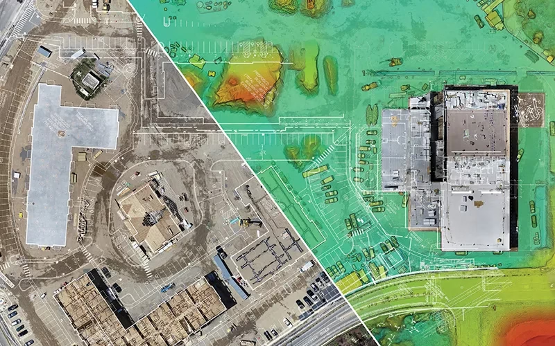
Topographic Survey
Before towering skyscrapers kiss the clouds and bridges stretch across rivers, there’s an unsung hero behind the scenes—Topographic Survey. It's not just about measuring land; it's the art of unlocking nature's hidden stories, revealing every curve, slope, and peak. This isn’t just a technical job—it’s a narrative of landscapes waiting to be unveiled. From laying the foundation for city wonders to safeguarding the beauty of untouched terrain, Drone For Surveying is where precision meets potential.
Are you curious about how the world gets mapped with flawless detail? Let’s uncover the craft that brings our world to life!
Get a Quote
What Is Topographic Survey
Topographic Survey is like writing the land’s biography—a vivid story of its peaks, valleys, and every twist in between. It’s the art of measuring and mapping the Earth’s surface, capturing everything from natural features like hills and valleys to human-made marvels like roads and buildings.
Imagine creating a 3D snapshot of the ground but with razor-sharp accuracy. This data forms the blueprint for architects, engineers, and planners, helping them shape their visions while ensuring everything fits seamlessly with the terrain. In a nutshell, Drone For Surveying transforms raw landscapes into powerful insights, where exploration meets innovation!
Applications Of Topographic Survey
The applications of topographic Surveys stretch across various fields. Each field benefits from the intricate details these surveys provide

Civil Engineering
Drone For Surveying makes road design possible. They also back the drainage system and bridge design. These Survey Drones provide invaluable information about the contours of the terrain. They also give information on elevation changes.

Land Development
Drone For Surveying are essential to residential development planning procedures. They have an impact on commercial development zoning as well. This guarantees that decisions are well-informed.

Environmental Studies
To evaluate ecosystems, these Survey Drones are crucial. They aid in watershed management. Drone For Surveying also helps with land use planning. When combined, they promote a thorough comprehension of our surroundings.
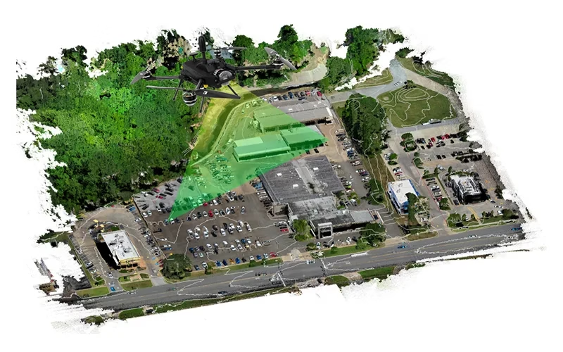
Architecture
Topographical studies influence the architecture of structures. The surrounding landscape also serves as a guide for building layout. This guarantees that buildings and their natural environments coexist peacefully.

Mining And Resource Extraction
They make it easier to carefully organize extraction procedures. They aid in the management of these procedures as well. They also accurately identify the locations of resources.
Deliverable Outputs Of Topographic Survey
The fruits of a topographic survey manifest in several critical deliverables. Each deliverable contributes to the overall understanding of the surveyed area
These intricate visual renderings depict contours. They also display important features and elevations. When combined, they provide a visual story of the landscape.
Three-dimensional models offer deep insights into the surface of the land. Drone Survey Mapping also shows change in elevation. These models are the foundation of analysis.
Drone Survey features are carefully represented in computer-aided design files. They establish the foundation for later engineering designs. Architectural designs are also supported by these files.
These documents are thorough. Methodologies, conclusions, and consequences are all contained within them. Drone Survey offers a development roadmap for projects.
Geographic Information System data integrates seamlessly into spatial analysis tools. This integration enables further study and planning.
These deliverables allow stakeholders to analyze road conditions. They help optimize route planning and conduct ongoing maintenance efficiently. Ultimately, this improves the quality and sustainability of road infrastructure projects.
2D Mapping
2D mapping offers a lens to depict spatial data in two dimensions. This data is typically showcased through flat maps. Survey Drones display a myriad of features, such as roads, buildings, and rivers. They use contour lines, symbols, and color gradations. While providing a simplified view of the terrain, these maps serve as invaluable tools. They are essential for navigation, planning, and analysis.
Characteristics
3D maps provide a sense of depth. They enable users to understand the subtleties of changes in landscape. Additionally, building heights are remarkably clear to users.
These depictions include surface elevation information. This data enables analysis and modification. It facilitates simulation as well.
A lot of 3D maps have interactive components. Users can zoom, rotate, and explore regions in real time with these pieces. This makes interacting with the landscape interesting.
Applications
To imagine future growth, city planners employ 3D mapping. They evaluate how these advances affect the environments around them. This exercise encourages deliberate development.
For the assessment of natural risks, 3D maps are essential. They support ecological change and water flow analysis. These maps provide a window into actual situations.
Virtual reality apps use these maps for training. Additionally, users employ them in planning and education. These maps offer immersion. They enthrall users.
Deliverables
They render terrain and architecture in great detail. Software like CAD or GIS frequently creates these representations. They encapsulate the environment's spirit.
Stunning illustrations depict realistic projects. They improve stakeholder evaluations and presentations.
Interactive platforms allow users to navigate through 3D environments. These platforms are ideal for tourism or real estate ventures.